Jose Mier Chronicles Second Unhealthy Day
If you’ve read my past Jose Mier blog posts you know that a recurring topic this fire and smoke. Even before the outbreak of our many fires in Southern California I wondered if Sun Valley was due for some sort of fire incident. It’s really impossible not to make smoke a topic. All one needs to do is walk outside the front door and breathe the contaminated air that had been plaguing us for the past few days.
Those of us in California, Oregon and Washington are all dealing with similar situations. The air in Sun Valley has a noticeable odor to it, unmistakably that the fire and smoke. And we know that there are fires burning close by such as the El Dorado fire and that winds are blowing the smoke from these fires right at us.
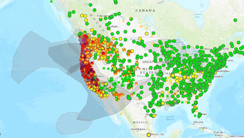
With all the talk about fire and smoke in our community it prompted me once again to find a fire and smoke map to see the extent of the smokiness. I did find such a map located on the airnow.gov website. You can view a screenshot of my map below. As you’ll see it looks as if the entire west coast of the United States is engulfed in a smoky cloud. The smoke stretches from Baja California up to Canada.

I honestly don’t know why I do this because the results depress me. It appears as though there’s no relief in sight and that we’re going to be breathing this foul air for some time. Smoke is been obscuring the sun for the last two days as well making things look like a winter overcast day or twilight when in reality it’s high noon. As if we didn’t have enough depressing things to worry about now we’re suffering prematurely from seasonal affective disorder.
I’ll continue to keep an eye on this map progress of other fires as well as the smoke and report on it as conditions change or updates are warranted. In the meantime it looks like you, me and the rest of Sun Valley will be staying indoors and avoiding the air outside for a while longer.

